Tuesday, January 27, 2009

1/27/09 2:00PM Update

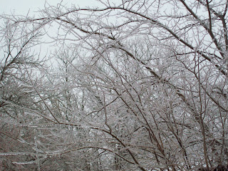
1" of ice and still accumulating at this time

Roads are ice
Cars are ice

Everything is ICE

Pictures below:


1/27/09 4:50AM

Significant Ice Totals from Elizabethtown on South while upto 4 inches of snow towards Louisville has fell since the beginning of the storm...

I've already received 1/2 inch ice accumulations with hardly any snow at all. Roads are passable in the central Kentucky area.

We will have a lull and depending on temperature tonights main storm could be worse then what we've received today.

Once daylight arises I will snap some photos of my little community.

All in all, Louisville got their snow. E'town will have a double shot of ICE STORM conditions that will lead to power outages and possible line breakages and limbs falling.

More this morning/early afternoon.

Monday, January 26, 2009

Television Station Predictions

Totals for each television station are as follows - Louisville only:

KEVIN HARNED - WAVE: 3-5"
JAMIE MARTIN - WHAS: 3-6"
MATT MILOSVICH: WLKY: 2-4" (Quote: With Alot of Stuff)
MARC WEINBURG: WDRB: 4-7" ( Emphasized Severe Icing in E'town )

These will be updated later this afternoon with more meteo predictions:

Just an update... Seems like possibly the warm air may win this and this become a SIGNIFICANT and DANGEROUS ICING Event Shaping up especially around Elizabethtown/Hardinsburg/Bluegrass Parkway Corridor.

More later.

Picture Problems

Having some picture problems that I can't figure out so expect a big summary of my thoughts on the storm including an overview on what each TV station is saying about it later this afternoon.

1/26/09 10:15AM

Winter Storm 2009:

Here are the new updates from HPC ( Hydrological Prediction Center ):

First the color codes for each legend posted:

  • RED - HIGH RISK 70% PROBABILITY
  • GREEN - MEDIUM RISK 40% PROBABILITY
  • BLUE - SLIGHT RISK 10% PROBABLITY
Second, This is the Monday probability for .25" of ice. The RED or High Risk extends into Central Kentucky from a starting point of about Richmond, Kentucky towards Paducah. I feel we will see this with warm air aloft will cause this type of precip. Ice storm conditions will develop overnight in Central Kentucky.


This is Tuesday .25" Probability Risk for our area. As you can see Central Kentucky is right in the bullseye for HIGH RISK. The Weather Channel is feeling this event will be more of an ice event as far north as Louisville and is mentioning upto 1 to 1 1/2" of Ice. They have mentioned several times " Crippling ". While I don't believe we will see that much ice and I don't think this will be like the lexington ice storm expect power outages and limbs down.


Having Computer Problems - I will finish my thoughts later on.


1/26/09 Early Morning #3: Issuance of Warnings!

As predicted, ICE STORM WARNING has been issued from Elizabethtown south and Winter Storm Warning has been issued from Elizabethtown north.


Expected totals remain the same for now and really don't expect them to change much unless something drastic changes today.


New NWS Louisville Map:


I have to give NWS Louisville credit as they are on the ball and all over this storm, as you can tell the other NWS officers hasn't made any changes except Louisville.


We have one of the best weather offices in the country and it is very obvious of such a bold quote.


Updates thru out the day

1/26/09: WINTER STORM WARNING!

Winter Storm Warning has been issued from 10 PM Monday Evening thru 10AM Wednesday Morning!